A team of U.S. surveyors visited Ecuador to use real-time PPP to pay homage to the 18th-century “Geodesic Mission to the Equator,” one of the most difficult and significant missions in the history of surveying and geodesy.
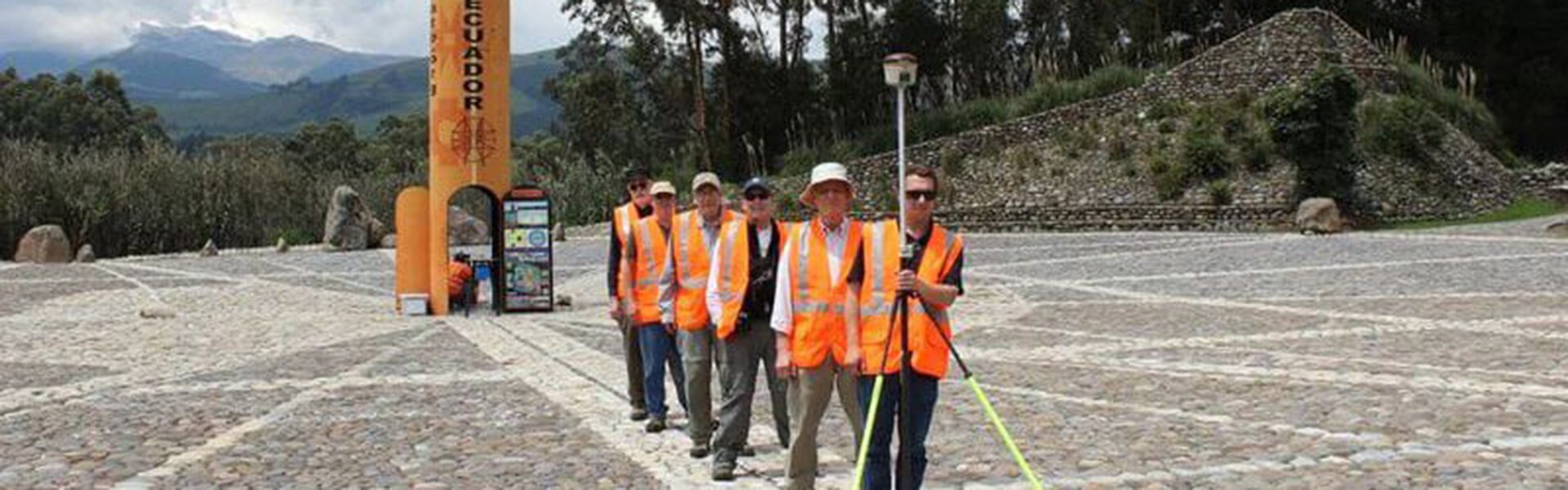
Pictured above: The team of U.S. surveyors on the 2017 Ecuador visit (from back to front): Rich Leu, John Hamilton, Ken Bays, Mark Armstrong, John Minor, and Joe Nunes (holding the Hemisphere S321 used for the commemorative survey). The team poses on the Equator at the Quitsato Sundial. Credit: Joe Nunes.
It is truly amazing how much the imaginary lines humankind has created to define the shape of our Earth have in turn served to define the physical manifestations of civilization and given form to the geospatial component of our imaginations.
Philosophers, scientists, explorers, adventurers—and eventually those who would be labeled “geodesists”—have sought for millennia to understand and define the true shape of the Earth. In the history of this quest one chapter stands out as the birth of modern geodesy. The 18th-century French/Spanish “Geodesic Mission to the Equator” was undertaken to provide the key measurements needed to resolve contentious debates on the shape of the Earth.
The mission was, in many ways, the single-most ambitious and difficult feat of geodetic surveying of its age. It was also the first truly international scientific mission and yielded significant discoveries far beyond the original charter.
The Geodesic Mission features prominently in the history of (and is celebrated in) Ecuador, a country named for the most famous of these imaginary lines. In May 2017 a small, informal “mission” of surveyors from the U.S., inspired by the Geodesic Mission, visited the capital of Ecuador, Quito, to tour sites of geodetic interest. To mark the occasion, the team performed brief observations and set a commemorative monument in cooperation with local parties.
Education was a key motivation for the 2017 mission. Potential entrants into the surveying profession and the science of geodesy must contemplate imaginary lines, esoteric conventions, and principles that might at first glance seem abstract or even absurd. The example of this 2017 team can be emulated by other groups of surveyors, in particular surveying students or even high school groups that can become immersed in the rich surveying and geodesy history of the region.
The Equator might be an imaginary line, but as the history of grand adventures like the Geodesic Mission (and this humble 2017 mission) reveal, what this line represents and its impacts on our world are real.
A Ripping Yarn
John Minor, PLS, a noted Oregon surveyor who recently retired, read a modern book examining the 18th-century Geodesic Mission to the Equator and was eager to compare notes with other surveyors on an online forum in mid-2016. I had read the same book, Measure of the Earth: The Enlightenment Expedition That Reshaped Our World, by Larrie D. Ferreiro, and several other books on the Geodesic Mission (cited by Ferreiro). We agreed: this book is one of the most fascinating reads—a must read—for surveyors and anyone else with an interest in geography and history.
Minor floated the idea of a group of surveyors visiting Quito, with easy access to the Equator and the northern starting point of the observations for the Geodesic Mission. xyHt staff helped plan the mission and found sponsorship for the commemorative observations on the Equator. The National Society of Professional Surveyors (NSPS) approved the mission as educational outreach and for cultural interaction with the Ecuadorian surveying community and geodetic authorities.
We all decided to seek a location to install the commemorative brass disk as close to the actual Equator as possible and verified by observations performed by the team. Minor researched travel plans, sites of geodetic and general interest to visit in and around Quito, and local transportation, and he sought fellow surveyors interested in joining the mission.
Hemisphere GNSS, a producer of GNSS hardware and software solutions for surveying, agriculture, marine, and construction, tapped one of their field application engineers, Joe Nunes, to join the mission. Hemisphere provided the equipment for the commemorative observations (see the sidebar, “PPP and Atlas”), in addition to sponsorship such as the ground transportation for the day of the observations.
Continue reading the article at xyHt.com